-
@maptrovecaeditor·
Victoria, BC Street Detail Wall Map
Detailed street map of Victoria, BC, shows transit, parks, and schools. Ideal for local navigation and reference.

-
@maptrovecaeditor·
Cardiff Map 1881
This map of Cardiff is sourced from high quality scans of historical Ordnance Survey maps from 1881.

-
@maptrovecaeditor·Toronto Downtown

Toronto Downtown Map showing streets, road names, transit routes, parks, landmarks, neighbourhood areas, Harbourfront, Toronto Islands, and downtown Toronto detail in a clear printed layout. Useful for local reference, office…

-
@maptrovecaeditor·
Southern Alberta and Saskatchewan Map
This map of Southern Alberta and Saskatchewan can be used to create personalized maps of the provinces. Buy this map from MapTrove.

-
@maptrovecaeditor·
Antique World Map
The map is among the top antique world maps for sale that can be ordered online at MapTrove to add an signature statement to your office or home

-
@maptrovecaeditor·
Humboldt, Saskatchewan Map from MapSherpa Street
The Humboldt Map from MapSherpa Street is ideal for businesses needing local or regional road network information within Humboldt, Saskatchewan.

-
@maptrovecaeditor·
Swift Current Saskatchewan Map
Swift Current is the fifth largest city in the Canadian province of Saskatchewan. This map shows all the primary details of the city like towns, municipalities, city boundaries, streets, major roads & highways, delivery points & catchment areas.

-
@maptrovecaeditor·
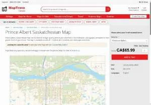
Prince Albert, Saskatchewan City Map
MapSherpa publishes a simple and easy-to-read city map of Prince Albert, Saskatchewan, Canada. The map includes an index of primary features.
-
@maptrovecaeditor·
Regina, Saskatchewan City Map
This multi-scale map of Regina, Saskatchewan, by MapSherpa, can be zoomed to a set location. Order online in paper, matte plastic and lamination finishes from maptrove.ca.

-
@maptrovecaeditor·
Saskatoon Neighborhood Map
MapSherpa Street products offers a Saskatoon neighborhood map. Ideal for business owners needing local or regional road network information within Saskatoon, Saskatchewan.

-
@maptrovecaeditor·
Australasia Political Wall Map
This political map of Australasia features countries marked in different colours, with international borders clearly shown. This political map of Australasia also contains city population detail, capital cities and all the major towns and cities in…

-
@maptrovecaeditor·
Antique World Wall Map - English and French
This world wall map features text in both French and English, making it ideal for schools, businesses, and public areas in Canada.

-
@maptrovecaeditor·
Illustrated Trivia World Map
This graphically appealing world map is a fun and informative resource, featuring colorful imagery, interesting notes, and facts about major regions.

-
@maptrovecaeditor·
NGA Nautical Chart 24028 Gulf of Paria to Maroni River
This NGA Chart 24028 (Gulf of Paria to Maroni River) is printed on demand using the most up-to-date NGA data from NOAA and provided by MapHouse LCC.

-
@maptrovecaeditor·
NGA Chart 24028 Gulf of Paria to Maroni River
NGA Chart 24028 is printed on demand with up-to-date data from NOAA. Provided by NOAA-certified chart agent MapHouse LCC. Maps of the Gulf of Paria and Maroni River.

-
@maptrovecaeditor·
NGA Nautical Chart 24012 Recife to Belmonte
This NGA Chart 24012, from Recife to Belmonte, is printed on demand using the most up-to-date NGA data available from NOAA at the time of print, provided by MapHouse LCC.

-
@maptrovecaeditor·
NGA Nautical Chart 24008: Belmonte to Rio de Janeiro
NGA Chart 24008 is a nautical chart of Belmonte to Rio de Janeiro. This chart is printed on demand using up-to-date NGA data available from NOAA.

-
@maptrovecaeditor·
NGA Nautical Chart 24000 Ilha de Santa Catarina to Maldonado
NGA Chart 24000 is printed on demand using up-to-date NGA data from NOAA and is provided by Certified NOAA chart agent MapHouse LCC for Ilha de Santa Catarina to Maldonado.

-
@maptrovecaeditor·
Derby Map by Maptrove
A map of Derby provides detailed street-level information, including extensive street labeling, useful for deliveries, home services, and real estate planning.

-
@maptrovecaeditor·
Coventry, England in 1887 - Historical Ordnance Survey Map
View a historical map of Coventry sourced from high-quality scans of Ordnance Survey maps published in 1887. Available from MapTrove.

-
@maptrovecaeditor·
Coventry Map
A map of Coventry providing detailed street level information. Perfect for delivery planning, home services, and sales territories.

-
@maptrovecaeditor·
Topographic Map of Estevan Point BC
Canadian topographic map of Estevan Point, British Columbia. NTS sheet 092E07 Edition 5.

-
@maptrovecaeditor·
Topographic Map of Nootka Sound BC
Canadian topographic map of Nootka Sound, British Columbia. NTS sheet 092E Edition 2.

-
@maptrovecaeditor·
Topographic Map of Lake Cowichan BC
This is a Canadian topographic map of Cowichan Lake, British Columbia. NTS sheet 092C16 Edition 3 from MapTrove.

-
@maptrovecaeditor·Little Nitinat River - 92 C/15 - British Columbia

Canadian topographic map of Little Nitinat River, British Columbia. NTS sheet 092C15 Edition 5.
